
India Officially Maps 27 Strategic Sites in Arunachal Pradesh to Counter China’s Claims..
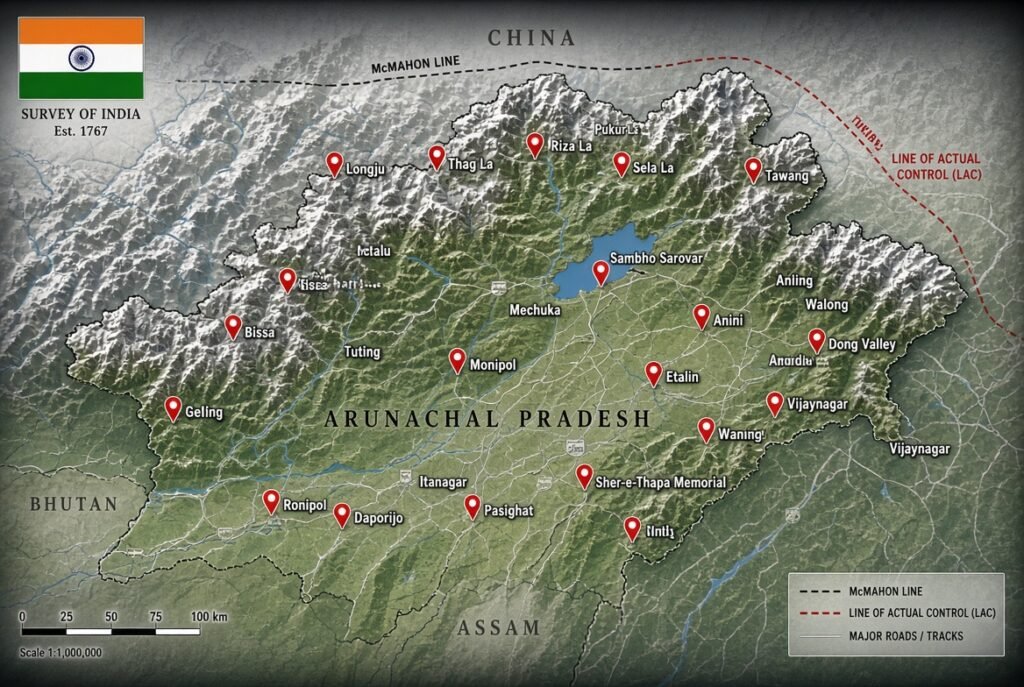
India has formally recognized 27 locations and geographical features in Arunachal Pradesh on the Survey of India’s official map, strengthening its territorial claims amid ongoing infrastructure development along the India-China border. The Indian government’s decision is seen as a response to China’s claim that Arunachal Pradesh is part of China. The Home Ministry shared this information on Friday. The list includes strategic locations such as Longju, Maja, and Bissa; mountain passes such as Thag La, Zo La, Riza La, and Pukur La; the high-altitude lake Sambho Sarovar; and the Sher-e-Thapa Memorial. Home Ministry officials stated that the move is aimed at ensuring a proper and definitive recognition of Arunachal Pradesh and responding to China’s repeated attempts to rename places in the region. Analysis of satellite imagery by independent monitors shows that China is building roads, camps, and other infrastructure near Jari in the disputed area. The area where India is changing the names of 27 places falls under the Indian-administered territory under the McMohan Line, but it was under Chinese control since 1959. Both these developments highlight the ongoing dispute related to infrastructure and maps on the Line of Actual Control (LAC), on which India says that such attempts at changing names and construction work cannot change the reality on the ground.
China Breaks Ground on Record,Breaking Hydropower Base in Tibet…
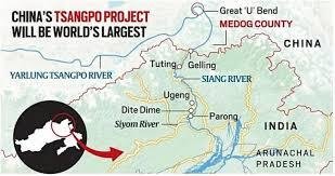
China’s decision to build the massive hydropower project on the Yarlung Tsangpo is significant because this river does not stay in China. It enters India through Arunachal Pradesh as the Siang, becomes the Brahmaputra River in Assam, and eventually flows into Arunachal Pradesh. Construction of the project officially began in 2025 and is expected to become the world’s largest hydropower development, generating roughly three times the electricity of the Three Gorges Dam. Why India is worried China sits upstream, giving it physical control over infrastructure that can influence river flows. Even if Beijing does not intend to cut off water, the ability to regulate releases gives it a strategic advantage during crises or periods of tension. Indian analysts worry that water could become another factor in the broader India-China rivalry. A major concern is not only reduced water flow but also sudden releases of water. If large volumes are discharged during heavy rainfall or emergencies, downstream regions in Arunachal Pradesh and Assam could face heightened flood risks. The Brahmaputra basin is already among the most flood-prone regions in the world. Although China says the project is primarily hydropower-oriented rather than a diversion scheme, Indian policymakers worry that dam operations could alter seasonal flows. Reduced water during dry months could affect agriculture, fisheries, river ecosystems, and local communities dependent on the river. The dam is being built in a geologically active part of the eastern Himalayas, an area prone to earthquakes, landslides, and fragile ecosystems. Environmental groups have warned that a project of this scale could affect biodiversity and sediment transport throughout the river basin. Probably not in the simplistic sense often portrayed on social media. The Brahmaputra receives enormous amounts of water from rainfall and tributaries inside India, especially in Arunachal Pradesh, Assam, and Bhutan. By the time the river reaches Assam, much of its flow comes from sources beyond Tibet. This limits China’s ability to completely control the river. Some experts therefore argue that fears of China shutting off the Brahmaputra are exaggerated. However, even partial control over timing, storage, and release of water can have important consequences for flood management, drought conditions, and regional security. That is where India’s concern is concentrated. How this could change Brahmaputra geopoliticsWater security becomes a national-security issue Traditionally, border disputes and military deployments dominated India-China tensions. The dam adds a new dimension: control of critical natural resources. Water security may increasingly be discussed alongside territorial security. India is accelerating its own dam projects India has explored large storage and hydropower projects in Arunachal Pradesh, including the proposed Upper Siang project, partly to create a buffer against any upstream manipulation and improve flood control. Bangladesh becomes an important stakeholder Because the Brahmaputra ultimately flows into Bangladesh, Dhaka also has an interest in any changes to river management. This could lead to greater regional diplomacy involving China, India, and Bangladesh over shared water resources. More pressure for data sharing and agreements Unlike some international rivers, the Brahmaputra lacks a comprehensive basin-wide water-sharing treaty among all riparian states. The mega dam may increase demands for transparency, hydrological data sharing, and formal mechanisms to manage disputes. Bottom line India’s concern is less about China literally stopping the Brahmaputra and more about China’s ability to influence the river’s timing, storage, and flow from an upstream position. The project introduces environmental, flood-management, and strategic uncertainties into an already sensitive border region. Whether it becomes a source of cooperation or tension will depend largely on transparency, data sharing, and how the dam is ultimately operated once it comes online in the 2030s.